
How Urban Sprawl Is Reshaping Canada’s Landscape (And Why It Matters for Our Future)
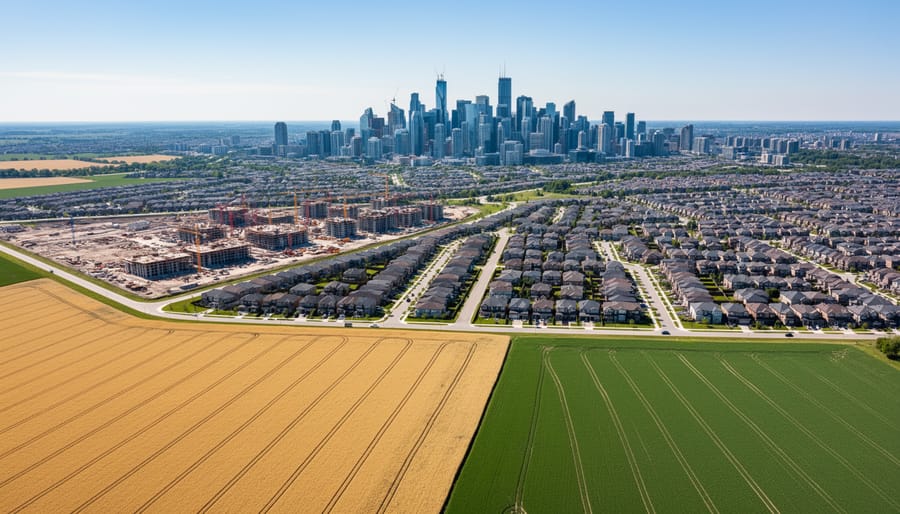
The Greater Toronto Area sprawls across 7,000 square kilometers, consuming farmland at a rate of 175 acres per day. What began as post-war optimism about suburban homeownership has transformed into one of Canada’s most pressing environmental and social challenges, affecting everything from carbon emissions to community cohesion.
Urban sprawl isn’t just expanding our cities outward. It’s reshaping how newcomers settle, where families can afford to live, and whether our communities can sustain themselves for future generations. In Vancouver, the average commute has stretched to 29 kilometers as affordable housing pushes further from city centers. In Calgary, low-density development consumes three times more land per capita than it did in 1980. These patterns create a cascade of consequences that touch every aspect of urban life.
The numbers tell a stark story. Canadian cities lose roughly 20,000 hectares of agricultural land annually to development, most of it prime farmland near urban centers. Transportation now accounts for 25% of Canada’s greenhouse gas emissions, driven largely by car-dependent suburban communities. Infrastructure costs in sprawling neighborhoods run 40-60% higher per household than in compact developments, straining municipal budgets and taxpayer dollars.
But here’s what makes this issue particularly complex for Canada: we’re a nation built on immigration, welcoming 400,000 newcomers annually. Most settle in our largest metropolitan regions. How we accommodate this growth determines whether we build sustainable, inclusive communities or perpetuate patterns that isolate families, drain resources, and accelerate climate change.
Maria Chen arrived in Mississauga three years ago, settling in a subdivision 45 kilometers from her downtown Toronto job because that’s where she could afford a home. Her daily reality includes two hours of commuting, limited access to transit, and a neighborhood where connecting with others requires driving everywhere. Her experience isn’t unique. It reflects choices made by planners, developers, and policymakers that ripple through communities for decades.
What Urban Sprawl Really Means in the Canadian Context
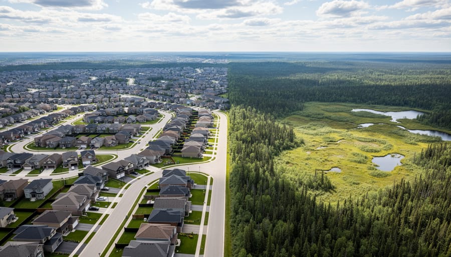
When Canadians drive through the outer edges of their cities, they’re witnessing a phenomenon that shapes everything from commute times to carbon emissions. Urban sprawl is the outward expansion of cities into previously undeveloped land, characterized by low-density housing, automobile dependence, and the conversion of agricultural or natural areas into residential subdivisions and commercial strips. But in Canada, sprawl takes on distinctive characteristics that set it apart from similar patterns in other countries.
Consider the view from an airplane window approaching Toronto or Calgary. You’ll see something remarkable: subdivisions stretching far beyond the urban core, connected by highways and punctuated by big-box retail plazas. These aren’t the compact European-style neighborhoods many newcomers might expect. Instead, they reflect a uniquely Canadian tension between abundant land and the practical realities of servicing far-flung communities.
- Urban Sprawl
- The unplanned, low-density expansion of cities outward into rural or natural areas, typically characterized by automobile dependence and separated land uses. In Canada, sprawl often leaps across greenbelt boundaries due to land availability.
- Greenfield Development
- Construction on previously undeveloped agricultural or natural land at the edges of urban areas. This contrasts with infill development, which builds within existing city boundaries.
- Leapfrog Development
- A sprawl pattern where development jumps over existing built areas to reach cheaper land further out, leaving gaps that increase infrastructure costs and service delivery challenges.
- Suburban Expansion
- The growth of residential areas beyond city cores, typically featuring single-family homes, car-oriented design, and lower population density than urban centers.
- Density
- The number of people or housing units per unit of land area, measured as persons or dwellings per hectare or square kilometer.
What makes Canadian sprawl unique is our geography. With the second-largest land mass in the world but a relatively small population concentrated along the southern border, we’ve developed differently than space-constrained nations. Take Maria Chen, who immigrated from Hong Kong to Mississauga in 2018. She was astonished by how far people drove for everyday tasks. “Back home, everything I needed was within walking distance,” she recalls. “Here, the grocery store is a ten-minute drive, and my son’s school is even farther.”
The distinction between sprawl and controlled urban growth matters enormously. Planned expansion includes infrastructure first, integrates transit, preserves green spaces, and builds at densities that support local services. Sprawl, by contrast, follows developer-driven patterns where houses appear before adequate transit, schools, or community amenities exist.
The Forces Driving Urban Sprawl Across Canada
Immigration and Population Growth as Catalysts
Canada welcomed over 437,000 permanent residents in 2022, part of an ambitious national strategy to grow the population and economy. These newcomers need homes. The challenge is that our housing supply hasn’t kept pace, and when cities struggle to build adequate housing within existing urban areas, the pressure pushes development outward into surrounding farmland and natural spaces.
Consider the experience of Priya and Samir, who arrived in Toronto from India in 2021. They quickly discovered that rental apartments in walkable neighbourhoods cost well beyond their budget. After six months of searching, they purchased a townhouse in a new subdivision 65 kilometers from the city center. “We wanted to live closer to work and transit,” Priya explains, “but the math just didn’t work.” Their story reflects a pattern playing out across Canada’s major metropolitan areas.
The Parliamentary Budget Officer has documented immigration’s impact on housing demandshowing how population growth intensifies the need for diverse housing options. The economic benefits are clear: newcomers fill labour shortages, start businesses, and contribute tax revenue that supports infrastructure and services. Statistics Canada reports that immigrants account for nearly 80 percent of labour force growth, essential for supporting our aging population.
But this growth creates land use dilemmas. When municipalities lack the political will or zoning flexibility to densify existing neighbourhoods, developers turn to greenfield sites on city edges where land costs less and approvals come faster. The result is suburban expansion that consumes agricultural land and increases infrastructure costs for roads, water systems, and utilities that taxpayers ultimately fund.
The solution isn’t reducing immigration. Rather, it requires aligning our housing policies with demographic realities, building more diverse housing types in established areas, and creating complete communities where newcomers can actually afford to live.
The Housing Affordability Equation
For many newcomers to Canada, the dream of homeownership crashes against the reality of urban housing prices. Consider the Ahmed family, who arrived in Toronto from Egypt in 2019 with professional credentials and savings. After months of searching, they discovered that a modest three-bedroom home in the city would consume nearly their entire down payment and require mortgage payments exceeding half their income. The same search in Barrie, 100 kilometers north, revealed houses priced at 40% less.
This scenario plays out thousands of times across Canadian cities. In Vancouver, the median detached home price hovers around $2 million, while similar properties in Abbotsford or Chilliwack sell for $800,000 to $900,000. The price differential creates an almost irresistible pull toward suburban and exurban areas, particularly for families seeking space and stability.
Recent immigrants face additional pressures. Many arrive with children or plans to start families, making the appeal of a backyard and good schools particularly strong. Without established credit histories or networks to access competitive mortgages, they’re already at a disadvantage in competitive urban markets. Suburban developers have recognized this demand, actively marketing to newcomer communities with promises of affordable family living.
Transportation costs complicate the equation. While suburban homes cost less upfront, families like the Ahmeds now spend $600 monthly on gas and car maintenance, plus 90 minutes each way commuting. But the monthly housing savings still outweigh these expenses in their calculation, a math that perpetuates sprawl even as it strains infrastructure and increases carbon footprints. Breaking this cycle requires addressing the root cause: making urban housing genuinely accessible to families at various income levels.
The Environmental Toll on Canada’s Land and Ecosystems
The Disappearing Farmland Crisis
Canada loses nearly 319 square kilometers of prime farmland every year to urban development. That’s roughly the size of Vancouver disappearing from our agricultural land base annually. The Greater Toronto Area stands at the epicenter of this crisis, where some of the country’s most fertile soil lies directly in the path of expanding suburbs.
Take the case of the Holland Marsh, just north of Toronto. This rich agricultural region has fed Canadian families for generations, producing carrots, onions, and celery that stock grocery stores across Ontario. Yet development pressure continues to mount. Farmers like Maria Santos, whose family has cultivated 50 acres of vegetables since immigrating from Portugal in the 1970s, face difficult choices. “Developers call every month,” she shares. “They offer money we could never make from farming. But if we all sell, where will the next generation’s food come from?”
The numbers tell a sobering story. Research shows that agricultural land conversion rates have accelerated in regions experiencing rapid population growth, often driven by immigration to major urban centers. The irony cuts deep: newcomers seeking better lives contribute to settlement patterns that ultimately threaten the agricultural capacity needed to support growing populations.
British Columbia’s Fraser Valley faces similar pressures. The region produces over 200 agricultural commodities, yet housing developments creep steadily across berry farms and dairy operations. Between 2011 and 2021, Metro Vancouver lost approximately 2,000 hectares of farmland despite Agricultural Land Reserve protections intended to preserve these areas.
This farmland crisis extends beyond food production. Local agriculture provides employment pathways for many immigrants, supports cultural food traditions, and reduces transportation emissions. Once paved over, this irreplaceable resource rarely returns to cultivation.
Wildlife and Ecosystem Fragmentation
When suburban development pushes into forests, wetlands, and grasslands, the consequences for wildlife extend far beyond the immediate construction zone. Animals don’t recognize property boundaries. A new subdivision might occupy only a few hundred acres, but its impact ripples across entire ecosystems, disrupting migration routes, breeding grounds, and the delicate connections that keep natural systems functioning.
Consider the experience of suburban Calgary, where rapid expansion into the foothills has fragmented critical habitat for species like elk, deer, and black bears. Wildlife corridors that once allowed animals to move freely between feeding and breeding areas have been cut into disconnected patches. Roads slice through these areas, creating dangerous crossings where vehicle collisions with wildlife have increased significantly. A 2019 study found that habitat fragmentation in Alberta’s expanding urban regions contributed to a 30 percent decline in certain bird populations over a single decade.
The problem compounds itself. When a forest becomes islands surrounded by development, species that need large territories struggle to survive. Predators can’t find enough prey. Plants lose their pollinators. The genetic diversity of isolated animal populations weakens over time, making them more vulnerable to disease and environmental changes.
Maria Chen, an urban planner who immigrated to Toronto from Singapore, saw these patterns firsthand when working on development projects in the Greater Golden Horseshoe region. “We’d approve a subdivision here, a shopping center there,” she recalls. “Each seemed small on its own. But looking at satellite images over ten years, I realized we’d created a patchwork that cut right through the Oak Ridges Moraine ecosystem.”
Wetlands face particular pressure. These areas filter water, prevent flooding, and provide crucial habitat for amphibians, migratory birds, and countless other species. Yet they’re often viewed as empty land waiting for development. Southern Ontario has lost nearly 70 percent of its original wetlands, largely to urban expansion.
The effects reach into unexpected places. When development eliminates natural predators and disrupts ecosystems, populations of certain species explode, creating new problems. Deer overpopulation in fragmented suburban habitats leads to increased Lyme disease transmission and damage to remaining forest understory.
Real Stories from Canada’s Sprawling Communities
The Sharma family arrived in Brampton from India in 2018, drawn by promises of affordable housing and good schools. They found a newly built four-bedroom home in a subdivision where the streets still smelled of fresh asphalt. “We could never afford this space in Toronto,” says Priya Sharma, watching her two children play in their fenced backyard. “Here, they have room to grow.”
Their story mirrors millions of newcomers who settle in Canada’s sprawling suburbs. Statistics show that 60 percent of immigrants to the Greater Toronto Area now choose suburban municipalities over the city core. The math is simple: housing costs half as much, and the schools have good reputations.
But the Sharmas also face challenges they didn’t anticipate. Priya’s husband commutes 90 minutes each way to his job in downtown Toronto. Their monthly transit costs exceed $500, and he arrives home exhausted. “We have space, but we’ve lost time,” Priya admits. The family owns two cars out of necessity. The nearest grocery store sits two kilometers away, unreachable by sidewalk in winter.
Contrast this with the experience of Marcus Chen in Markham. His family moved there in 2015, just as the city was investing heavily in transit-oriented development. Their townhouse sits within walking distance of a community center, library, and the future location of a light rail station. “We chose this neighborhood specifically because we could imagine life without always driving,” Marcus explains. His teenage daughter bikes to school, and the family uses car-sharing services for weekend trips rather than owning a second vehicle.
Sarah Okonkwo’s experience in Calgary’s suburban McKenzie Lake subdivision tells yet another story. The Nigerian-Canadian nurse appreciates her neighborhood’s diversity and the community gardens that dot the area. “People from 30 different countries live on my street,” she says. “We’ve created something special here.” However, she notes that accessing cultural groceries, places of worship, and community services requires significant travel. Her mosque is a 25-minute drive away.
These experiences reveal urban sprawl’s complex reality. Newcomer families gain space and relative affordability, advantages that genuinely improve quality of life. Children have yards. Parents can afford larger homes than would ever be possible downtown.
Yet the trade-offs accumulate. Long commutes steal family time. Car dependency increases household expenses and environmental footprints. Social isolation can develop when neighborhoods lack walkable gathering spaces. The promised suburban dream sometimes delivers a different reality than expected, particularly for families relying on public transportation or trying to maintain connections to cultural communities concentrated in urban cores.
The Social and Economic Consequences
Infrastructure Strain and Municipal Budgets
Urban sprawl doesn’t just consume land. It drains municipal wallets for decades to come. When cities expand outward instead of building up, they create a hidden financial burden that many residents don’t see until property taxes rise or services deteriorate.
The math is straightforward but sobering. Every kilometer of new road, water pipe, and sewer line in low-density neighborhoods costs the same to build and maintain as infrastructure in denser areas, but serves far fewer taxpayers. A single-family home on a large suburban lot generates significantly less tax revenue per hectare than a mid-rise apartment building, yet requires the same connections to water, electricity, and transit networks.
Consider the story of Barrie, Ontario, where rapid expansion northward in the 2000s seemed like progress. The city extended services to new subdivisions, adding fire stations, snowplows, and bus routes. But infrastructure cost comparisons reveal that these sprawling neighborhoods cost the city roughly 40 percent more per household to service than established areas closer to downtown.
This pattern repeats across Canadian cities. Calgary’s sprawl means maintaining infrastructure across 848 square kilometers for 1.3 million people. The city’s Finance Department has warned that current growth patterns aren’t financially sustainable without significant property tax increases.
The challenge intensifies as infrastructure ages. Those pipes and roads eventually need replacement, creating a maintenance debt that future residents inherit. Many growing cities, particularly those welcoming newcomers, face a choice: continue spreading outward and risk fiscal strain, or redirect growth toward existing neighborhoods where infrastructure already exists and can serve more people efficiently.
Community Connection and Newcomer Integration
For newcomers arriving in Canada, the physical layout of their new community profoundly shapes their integration experience. Low-density suburban developments, spreading across the outskirts of major cities, present unique challenges for those seeking to build social connections and find their place in Canadian society.
Consider Maria, who arrived in Mississauga from the Philippines in 2019. Her family settled in a suburban subdivision where homes sat on large lots, separated by wide streets with minimal sidewalk infrastructure. “I felt isolated,” she recalls. “Back home, I could walk to the market, meet neighbors, bump into friends. Here, I needed a car to go anywhere, and I rarely saw people outside.” This experience reflects a broader pattern: sprawling neighborhoods lack the gathering spaces, the corner stores, the community centers that naturally facilitate social interaction.
Research from the Wellesley Institute found that newcomers in car-dependent suburbs experience higher rates of social isolation compared to those in walkable, mixed-use neighborhoods. Without casual daily encounters that build familiarity and trust, integration slows. Cultural community organizations often cluster in older urban areas, making them inaccessible to suburban residents without reliable transportation.
The challenge extends beyond individual wellbeing. When newcomers can’t easily connect with established cultural communities or participate in local civic life, everyone loses. These neighborhoods miss out on the economic vitality, cultural richness, and diverse perspectives that immigration brings.
Yet some communities are responding. Brampton has invested in multicultural community hubs in suburban areas, creating spaces where newcomers can access services, attend cultural events, and meet neighbors. Transit improvements connecting suburban areas to urban cores also help, giving newcomers mobility and access to broader opportunities. These targeted interventions show that thoughtful planning can counter sprawl’s isolating effects.
Canadian Cities Leading the Way Toward Smarter Growth
Across Canada, several cities are charting a different course, proving that growth doesn’t have to mean endless sprawl. These communities are demonstrating how thoughtful planning, combined with political will and community engagement, can create vibrant, sustainable neighbourhoods that welcome newcomers while protecting green spaces and farmland.
Vancouver stands out as a pioneer in growth management through its Agricultural Land Reserve, established in 1973. This provincial policy protects over 4.6 million hectares of farmland from development, creating firm boundaries around urban expansion. The result? Metro Vancouver has achieved some of the highest residential densities in North America while maintaining productive agricultural land within sight of downtown towers. The city has also embraced “missing middle” housing, constructing townhouses, low-rise apartments, and laneway homes that increase density without requiring high-rises. Since 2009, Vancouver has permitted over 4,000 laneway homes, creating affordable rental units in established neighbourhoods and gently intensifying single-family areas.
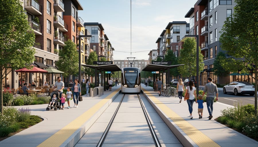
Toronto’s experience with transit-oriented development offers another compelling model. The city’s growth plan directs most new development to areas within walking distance of rapid transit stations. The transformation of the former industrial lands around the King-Spadina neighbourhood illustrates this approach beautifully. What was once a declining warehouse district is now home to over 30,000 residents in mid-rise buildings, all within steps of multiple streetcar and subway lines. Newcomer families, including recent immigrants from South Asia and the Middle East, have found affordable rental units here while maintaining easy access to jobs downtown and cultural communities across the city.
Calgary has made remarkable strides in shifting development patterns inward. The city’s plan, known as the Municipal Development Plan, aims to direct 50% of new growth to existing communities through infill and redevelopment. By 2019, Calgary had reached 29% infill growth, up from just 5% in the early 2000s. The East Village redevelopment transformed a neglected area near downtown into a thriving neighbourhood with 12,000 new residents, parks along the Bow River, and a mix of housing types that accommodate everyone from young professionals to senior citizens.
Halifax provides a maritime example of balanced growth. The city’s regional plan established urban settlement boundaries and directs growth to five regional centres connected by transit. The Dartmouth Crossing area demonstrates how careful planning can transform car-dependent retail sprawl into mixed-use communities. Recent rezoning efforts prioritize housing above commercial spaces and improved pedestrian connections, slowly retrofitting suburban development into more complete neighbourhoods.
Ottawa’s Lansdowne Park redevelopment shows how cities can reimagine underutilized urban land. This project transformed a sprawling stadium site near the downtown core into a mixed-use neighbourhood with residential units, retail, parks, and cultural venues. The development preserved heritage buildings while adding housing for 1,200 residents without consuming a single hectare of farmland on the urban fringe.
These cities share common strategies: they’ve established clear growth boundaries, invested heavily in public transit before approving high-density development, and created diverse housing types to accommodate various household sizes and income levels. They’ve also engaged communities in planning processes, helping residents understand that gentle intensification can enhance neighbourhood character rather than destroy it.
The success stories aren’t without challenges. Resistance from existing homeowners, development industry pushback, and the complexity of coordinating multiple levels of government remain ongoing obstacles. But these cities prove that alternatives to sprawl are viable, economically sound, and can create the kind of welcoming, sustainable communities that both long-time residents and newcomers deserve.
Solutions That Balance Growth with Sustainability
Densification Done Right
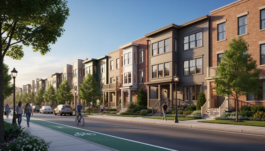
The good news is that cities can grow without spreading outward. Gentle density offers a middle path between single-family neighborhoods and high-rise towers, allowing communities to accommodate more people while preserving the qualities that make neighborhoods livable.
Missing middle housing includes duplexes, triplexes, townhomes, and small apartment buildings. These housing types were common in Canadian cities before mid-century zoning laws essentially banned them. Today, communities are rediscovering their value. A duplex on a standard lot looks nearly identical to a single-family home but houses two families instead of one. A well-designed fourplex can fit comfortably into an established neighborhood while quadrupling the number of people who can live there.
Vancouver’s laneway housing program demonstrates how cities can add density without disrupting neighborhood character. Since 2009, homeowners have built over 6,000 small secondary units in backyards across the city. These modest homes provide affordable options for newcomers, young families, and aging parents who want to stay close to their children. Walk down any residential street in East Vancouver and you’ll spot these compact dwellings tucked behind existing houses, invisible from the front.
Montreal’s Plateau neighborhood shows what gentle density looks like at scale. The area’s iconic outdoor staircases lead to second and third-floor apartments in buildings that maintain human scale. Tree-lined streets remain walkable. Corner stores thrive. Families know their neighbors. The density supports frequent transit service and local businesses while consuming far less land than suburban subdivisions.
These approaches prove that growth doesn’t require choosing between sprawling suburbs and impersonal towers. Communities can welcome newcomers and long-time residents alike in neighborhoods that feel like home.
Regional Planning and Collaboration
Urban sprawl doesn’t respect municipal boundaries. A city might adopt progressive land-use policies, but if the neighboring town continues approving low-density subdivisions and big-box developments on greenfield sites, the environmental and social costs ripple across the entire region. This is why coordinated regional planning has become essential for communities serious about managing growth sustainably.
The Greater Toronto and Hamilton Area offers a compelling example of what regional coordination can achieve. In 2006, the provincial government introduced the Growth Plan for the Greater Golden Horseshoe, requiring municipalities to work together on land-use decisions. The plan established density targets for new development, protected agricultural land, and directed growth to already-built areas. While implementation hasn’t been perfect, the framework prevented an estimated 260,000 acres of farmland and natural areas from being converted to sprawl between 2006 and 2021.
Regional transportation planning matters just as much as land-use coordination. Metro Vancouver’s TransLink operates across 21 municipalities, linking transit systems, cycling infrastructure, and land-use planning. This integrated approach means new residential developments in Surrey connect to job centers in Vancouver through reliable transit, reducing car dependency. For newcomers settling in the region, this connectivity translates to real opportunities for employment and community participation without requiring immediate vehicle ownership.
Priya Singh moved to Mississauga in 2019 and initially struggled with the car-centric layout. “My husband and I shared one vehicle for two years,” she recalls. “Regional GO Transit expansion meant I could reach Toronto for work, but local trips were difficult.” Regional planning that prioritizes transit across municipal lines directly affects how newcomers experience settlement and integration.
Successful regional collaboration requires political will and dedicated governance structures. Metro Vancouver’s board brings together representatives from member municipalities to make decisions about regional parks, water systems, and growth strategies. This shared decision-making prevents a race to the bottom where municipalities compete for tax revenue by approving sprawling developments, regardless of regional impacts.
Cross-border land preservation initiatives also demonstrate the power of regional cooperation. The Agricultural Land Reserve in British Columbia protects farmland across multiple jurisdictions, recognizing that food security benefits the entire region, not just individual municipalities.
What You Can Do to Support Sustainable Communities
Combating urban sprawl isn’t just the responsibility of planners and policymakers. Each of us has the power to shape more sustainable communities through our daily choices and civic participation. For newcomers to Canada, these decisions often begin the moment you start searching for a place to call home.
Meet Amira, who arrived in Toronto from Egypt in 2019. Initially attracted to a suburban development 50 kilometers from the city center because of lower housing costs, she quickly realized the hidden expenses: two cars became necessary, commute times stretched to three hours daily, and her family rarely saw their urban neighborhood. When her lease ended, Amira made a different choice. She found a smaller apartment in a transit-oriented community closer to work. “We traded square footage for quality of life,” she says. “My daughter walks to school, I take the train to work, and we’ve actually saved money despite higher rent.”
Here are concrete steps you can take to support sustainable community development:
- Research housing options beyond traditional suburbs. Explore neighborhoods with good public transit connections, mixed-use development, and walkable amenities. Consider smaller homes in well-connected areas rather than larger houses requiring long commutes.
- Participate in municipal planning processes. Attend public consultations about new developments in your area. Many municipalities actively seek input on official plans, zoning changes, and transportation projects. Your voice matters, especially as newcomers bring fresh perspectives.
- Support transit-friendly development. When developments are proposed near transit stations or along major corridors, show up to council meetings or submit written support. These projects often face opposition but are crucial for reducing sprawl.
- Advocate for diverse housing types. Push for townhomes, low-rise apartments, and missing middle housing in your neighborhood. This variety makes communities more affordable and reduces pressure to build ever-outward.
- Choose walkable neighborhoods when possible. Prioritize locations where you can reach grocery stores, schools, and services on foot or by bike. This reduces your environmental footprint and strengthens community connections.
Beyond housing decisions, get involved locally. Join or start a community garden. These green spaces combat the loss of agricultural land to sprawl while building social connections. Support local businesses in urban cores and inner suburbs rather than big-box stores on the urban fringe.
Consider carpooling or advocating for better transit service in your area. Chen, a software developer from China living in Calgary, started a carpool group for parents at his son’s school. What began as a practical solution reduced 15 cars from the school run and sparked friendships across cultural backgrounds.
Your consumer choices matter too. Supporting farmers’ markets and local food systems reduces the pressure to convert farmland into subdivisions. These choices create ripple effects that extend far beyond individual actions.
Canada stands at a crossroads. The decisions we make today about how we grow our cities will shape communities for generations. Urban sprawl doesn’t have to be an inevitable consequence of welcoming newcomers or accommodating population growth. Instead, we can choose a different path.
Consider the story of Rajesh, who arrived in Mississauga five years ago and now volunteers with a local community garden initiative that transformed a vacant lot into green space. Or Maria, a recent immigrant to Montreal who lives in a mixed-use neighborhood where she walks to work, shops locally, and has built friendships with neighbors from around the world. These aren’t just feel-good anecdotes. They represent the kind of communities we can build when we prioritize smart growth over endless expansion.
The challenges are real. We need housing for growing populations. Infrastructure must expand. Economic opportunities must reach beyond city cores. But addressing these needs doesn’t require paving over farmland or creating car-dependent subdivisions. Cities like Vancouver have shown that density can coexist with livability. Communities across the country are discovering that infill development, transit-oriented neighborhoods, and mixed-use planning create vibrant places where both longtime residents and newcomers thrive.
This isn’t someone else’s responsibility. Every one of us plays a role. When you support local businesses within walking distance, advocate for better public transit, or participate in community planning meetings, you’re helping build a sustainable future. Newcomers bring fresh perspectives on urban living, often from places where walkable neighborhoods and public transit are the norm.
Canada’s greatest strength has always been its ability to adapt and innovate. We can accommodate growth while protecting the natural landscapes that define us. We can create inclusive communities where connection matters more than square footage. The future isn’t predetermined. It’s ours to shape, together.

No comments.